
Inland Flooding
Flash Flooding

Flash flooding can occur in urban and low-lying areas after short periods of very heavy rainfall. Training thunderstorms, most common during the summer, are slow-moving storms that repeatedly produce heavy rain over the same area within a short window. Flash floods can also occur during a drought because heavy rainfall cannot be absorbed if the soil is too dry.
River Flooding

Rhode Island is home to several large rivers, including the Blackstone, Pawcatuck, Pawtuxet, Wood, and Woonasquatucket. During unusually wet periods, these rivers (and their tributaries) can flow beyond their normal banks into their floodplain. Before human settlement, the floodplains of Rhode Island’s major rivers flooded regularly, especially during the spring months.
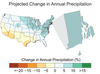
Connection: Inland Flooding and Climate Change
Rhode Island has already seen an increase in annual precipitation in recent decades. Extreme precipitation events (i.e., those with the top 1% of daily precipitation accumulations) have increased 60% in the Northeast U.S. due to climate change. (1) The continuation of this trend will exacerbate future flash flooding and river flooding in Rhode Island.
The adjacent map displays the projected change in total annual precipitation (%) for the middle of the 21st century compared to the late 20th century under a higher emissions pathway. Hatching represents areas where the majority of climate models indicate a statistically significant change. (12)
Significant Inland Floods
Many inland floods have occurred throughout Rhode Island’s history, and the following events are highlighted for their severity and damage to life and property. It is important to note the magnitude of inland floods (i.e., rainfall, streamflow, water levels, etc.) were rarely quantified before the establishment of important infrastructure.
-
January 1770
One of the first significant inland floods to impact Rhode Island occurred in January 1770. Accounts at the time note “… a great flood [on the Pawtuxet River]… many mills, bridges, etc., carried away…rivers higher than they have been known these 30 years, some say 50. The quantity of rain was great, being 3 inches and 8/10." (2)
-
January 1784
Eight years after American Independence, a significant flood impacted the Moshassuck River in Providence. A historical account notes: “It was computed that the destruction wrought by this flood was nearly as great, relatively, as that caused by the burning of the town in the King Phillip War, and that only the opportunity afforded by the Cove for the waters to spread and abate their force saved the town street from total destruction”. (2)
-
February 1823
The term freshet is an older term used to describe flooding from the combination of rain and snow melt. In February 1823, a significant rain-on-snow event caused flooding along the Pawtuxet River. Significant damage occurred: “About one o’clock that night, the bridge on the Providence and Pawtucket turnpike, which spanned the Pawtuxet River at Natick, in Rhode Island, was carried away whole. The bridge on the old road, which was then commonly called Natick Bridge, and a bridge on Olneyville were also destroyed. The bridge at the Arkwright factory, and another at the Hope factory were considerably damaged, but remained passable. At Pawtuxet, the river had risen as high as the bridge the next days and its abutments tottered but still held...” (3)
-
February 1867
In February 1867, a severe flood occurred in northern Rhode Island and Connecticut. At the time, it was remarked “…So great and disastrous a flood has not occurred there for over thirty years." This flood destroyed dams along the Chepachet River that held back Keech Pond and the Smith & Sayles Reservoir in Glocester. Rhode Island State Archives remark “A massive wall of water and debris caused extensive destruction along the river, washing out the dam at Factory Pond immediately upstream of Chepachet Village. This surge of water transformed the topography of the area, carving out the ravine that now defines the area immediately upstream of the bridge and destroying the timber bridge.” (2,7)
-
March 1876
By the late 1800s, Rhode Island was home to many mills that capitalized on the flow of water. In March 1876, a significant flood occurred along the Blackstone River in Pawtucket that rivaled the February 1867 event. "…[the Blackstone River] has rarely if ever, attained such a height. It was four or five inches higher in the Haircloth Mill than in 1867 where it is now 19 ½ inches on the floor". Another account from North Providence remarks "The damage by [the Woonasquatucket River] water in this vicinity was considerable. The highest water since 1867…" It is unknown how much rain fell to produce this flood. (2)
-
February 1886
The most severe and well-documented inland flood of the 19th century occurred in February 1886. Historical accounts from Pawtucket note, "The great flood on March 1876 has always been alluded to as the greatest on the river, but yesterday the water was two feet and four inches higher than at that time. There are four feet four inches of water in the Haircloth Mill floor. Maximum discharge was 21,000 cubic feet per second. There was eleven inches of rainfall…” An account from Providence mentions, “At Brayton Bridge the [Woonasquatucket River] water was higher than has been recorded at this point at any time within the last 40 years. The dam at Dyerville gave way.” In southern Rhode Island along the Pawcatuck River, “The flood was 2 ½ feet higher than any time since 1836. The highest water previous to 1886 was in 1784, at which time the water was one foot lower than 1886.” (2)
-
September 1936 – The September Hurricane of 1936
In September of 1936, a hurricane tracked close enough to New England (about 50 miles south of Nantucket) to bring very heavy rain to Rhode Island. The preceding weeks were wet, as Providence recorded 4.05” of rain from August 1 to just before the hurricane. An additional 3.99” of rain from this hurricane on September 18 and 19 caused a dam to break on the Woonasquatucket River, further exacerbating downstream river flooding. (4,5)
-
September 1954 – Hurricane Edna
Just two weeks after Hurricane Carol, Hurricane Edna made landfall on September 11 over the eastern end of Cape Cod. A storm surge of 4.1’ occurred in Providence, significantly lower than Hurricane Carol two weeks prior. While Rhode Island escaped major coastal flooding, 4.37” of rain from Hurricane Edna caused major flooding on all rivers. Saturated grounds from the 7.5” rainfall from hurricanes Carol and Edna (and a minor rain event in between) led to road washouts and inundated residential areas. (4,5)
-
August 1955 – Tropical Storms Connie and Diane
The worst inland flooding of the 20th century in Rhode Island occurred from rainfall dropped by back-to-back tropical storms in August 1955. From August 12-14, ~3” of rain fell from Tropical Storm Connie. Less than a week later, Tropical Storm Diane brought over 6” of rain to the state. These two storms combined for more 9” of rain in 10 days. Catastrophic flooding occurred along the Blackstone River, which rose 17’ above flood stage. The Horseshoe Dam in northern Woonsocket, a 90-year-old dirt-embankment at the time, failed and released a 20’ surge of water downstream. Sections of downtown Woonsocket were destroyed. Elsewhere in Rhode Island, road washouts and flooded basements were common. (4,5)
-
September 1961 – Hurricane Esther
Hurricane Esther was a unique storm to impact Rhode Island. Advancing at an unusually slow speed of 6 miles per hour, Hurricane Esther made a clockwise loop south of Cape Cod, first bringing 4”-6” of rain to Rhode Island on September 21. Four days later, an additional 1”-2” of rain fell on September 25. Urban and street flooding across the state followed, with the Pawtuxet River basin most affected. (4,5)
-
October 1962 – Hurricane Daisy
In October 1962, Hurricane Daisy passed well offshore New England and made landfall over southwest Nova Scotia. Rhode Island and southern New England received the brunt of Hurricane Daisy’s heavy rain. Over four days, T.F. Green Airport in Warwick recorded 9.43” of rain and Woonsocket recorded 7.86”. Widespread urban and lowland flooding occurred, and northeast Rhode Island was the hardest hit area. (4,5)
-
August 1976 – Hurricane Belle
Hurricane Belle produced both riverine and coastal flooding across Rhode Island. Prior to Belle’s arrival on August 9, a separate storm system produced 2”-3” of rain. Another 1.5”-2” of rain by Hurricane Belle resulted in considerable flooding of urban areas. Fox Point Hurricane Barrier in Providence was closed for the first time since its completion 10 years prior during Hurricane Belle. (4,5)
-
June 1998
June 1998 was Rhode Island’s wettest June, with a record 14.79” of rain falling in Foster. From June 12-15, a slow-moving storm system pulled ample tropical moisture into Rhode Island. Between 6” and 8” of rain fell across the state within three days. The ground was already saturated from a very wet spring, which caused most rivers to reach flood stage. The U.S. Geological Survey estimated the recurrence interval for peak flows on the Pawtuxet River during this event to equal a 15-year flood. (9,10)
-
March 2001
A series of storms caused minor to moderate flooding of the Blackstone and Pawtuxet rivers in March 2001. Woonsocket recorded 10.59” of rain, its second-rainiest March on record, and T.F. Green Airport in Warwick recorded 8.78” of rain. Combined with melting snow, the heavy rain caused the Blackstone River to crest at 11.65 (2.65’ above flood stage) and the Pawtuxet River to crest at 11.36’ (2.36’ above flood stage). Over 1,400 homes and 37 businesses were affected; the damage was estimated at $3 million. (9)
-
October 2005
In early October 2005, a slow-moving low-pressure system tapped into tropical moisture and caused extensive river flooding across Rhode Island. Rain fell for eight straight days from October 11-15, and over 4” were recorded across northern and central areas on the 15th alone. Residents were evacuated in low-lying areas adjacent to the Pawtuxet, Pocasset, Woonasquatucket, and Blackstone rivers. Many roads were closed due to the flooding, including a portion of state route 37 in Cranston. At the time, the Woonasquatucket River at Centerdale recorded a new flood stage record. Governor Carcieri declared a state of emergency following the flooding (9)
-
March 2010
The worst inland flooding in Rhode Island’s history occurred from March 30-31, 2010. The preceding month was unusually wet, as most of the state had already reached climatological normal rainfall by the 15th. A pair of two-day rainstorms dumped over 4” of rain from March 22-23 and over 8” of rain from March 30-31. Rainfall totals for the month exceeded 10” across all of Rhode Island, and the cooperative observer weather station at the University of Rhode Island set the state record for the all-time wettest month at 19.37”. Many roads adjacent to rivers, including I-95, were impassable and four dams throughout the state were breached. Over 500 people were evacuated from their homes and thousands lost power after many electrical substations were flooded. The Pawtuxet River reached a record crest of 20.79’ on March 31 (approximately 13’ above flood stage), surpassing the previous record of 14.98’ set just two weeks prior. Infrastructure directly adjacent to the Pawtuxet River was hardest hit, including the Warwick Mall and several wastewater treatment facilities that failed during the event. The flood resulted in hundreds of millions of dollars in damages, with $70 million in damages to businesses alone. For the Pawtuxet River, the floods of March 2010 were a 500-year event (0.2% of annual occurrence). (9,11)
-
December 2023 and January 2024
In December 2023 and January 2024, several powerful coastal storms impacted Rhode Island with heavy rain, wind, and significant coastal erosion along south-facing beaches. Both months were very wet, as parts of Rhode Island received over 200% of climatological normal precipitation. Many roads were impassable from flood waters as rivers and ponds swelled beyond their banks. The Pawtuxet River in Cranston crested at 15.11’ on December 19, the highest level reached since March 2010. A new state weather record for wettest December was set after a cooperative observer weather station in Foster recorded 13.46” of rain. In West Warwick, 40 people were rescued from their homes by boat after the January 2024 storms. (9)
References
- Huang, H., J. M. Winter, E. C. Osterberg, R. M. Horton, and B. Beckage, 2017: Total and Extreme Precipitation Changes over the Northeastern United States. J. Hydrometeor., 18, 1783–1798, https://doi.org/10.1175/JHM-D-16-0195.1.
- Historic Floods in New England (Thomson, Gannon, Hayes et al., 1964)
- Historic Storms of New England (Perley, 1891)
- Rhode Island Hurricanes and Tropical Storms: A Fifty-Six Year Summary 1936-1991 (Vallee, 1993)
- Southern New England Tropical Storms and Hurricanes: A Ninety-Seven Year Summery 1900-1996 (Vallee and Dion, 1997)
- Storm Tides in Twelve Tropical Cyclones (including Four Intense New England Hurricanes) (Jarvinen, u.d.)
- Rhode Island State Archives – Department of Transportation
- NCEI Storm Events Database – Coastal Flooding
- NCEI Storm Events Database – Inland Flooding
- The Flood of June 1998 in Massachusetts and Rhode Island (Parker, Ries, Socolow, 1998).
- Dodging Deluges (Kuffner, n.d.)
- Runkle, J., K.E. Kunkel, D.R. Easterling, B.C. Stewart, S.M. Champion, L.E. Stevens, R. Frankson, W. Sweet, and J. Spaccio, 2022: Rhode Island State Climate Summary 2022. NOAA Technical Report NESDIS 150-RI. NOAA/NESDIS, Silver Spring, MD, 4 pp. https://statesummaries.ncics.org/chapter/ri/