
The Rhode Island Department of Environmental Management (DEM) has issued a new general permit using its Residual Designation Authority to cover stormwater runoff in the Mashapaug Watershed, which includes Mashapaug, Spectacle, and Tongue Ponds in the Cities of Cranston and Providence, that aren't currently regulated under existing permits. The permit is designed to fill gaps in stormwater pollution control by requiring improvements in water quality using an adaptive management approach.
The Mashapaug General Permit requires property owners within the watershed with one (1) acre or more of impervious surface to implement pollution prevention and good housekeeping measures to manage, treat, and control stormwater from their site. Properties with the most impervious surface must develop and implement a site-specific Stormwater Management Plan (SWMP) that outlines how they will reduce or prevent stormwater pollution from their properties.
-
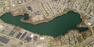
1.8 square miles in size
-
Includes three (3) Freshwater Ponds (Tongue, Spectacle, and Mashapaug)
-
Mashapaug Pond is the largest freshwater body in the City of Providence
-
Residential, commercial, and transportation uses occupy 83% of the watershed
-
Impervious surfaces cover a total of 61%
Petitions Submitted
The Clean Water Act (CWA) defines the specific construction, industrial, and municipal stormwater sources that must be authorized by a RIPDES Permit. RIDEM may use its “Residual Designation” authority (RDA) to require RIPDES Permits for other stormwater discharges or category of discharges on a case-by-case basis. It can also be requested by petition.
RDA petitions were published by the Conservation Law Foundation on November 19, 2018, and the Rhode Island Attorney General on January 31, 2024, which cited:
- Long-standing water quality impairments in the Mashapaug Watershed
- Current gaps in RIPDES stormwater permitting, addressed legacy pollution in an Environmental Justice Focus Area,
- Implement green infrastructure to reduce the negative effects of climate change and flooding
- Address properties not currently regulated that include ≥1 acre of impervious area
RIDEM Formal Response
RIDEM formally responded to the Mashapaug Watershed RDA Petition on April 30, 2024, by committing to issue a Mashapaug General Permit to regulate previously unpermitted stormwater discharges into Mashapaug, Spectacle, and Tongue Ponds in the Cities of Cranston and Providence, RI.
This initial work identified parcels or contiguous parcels with one (1) acre or more of impervious cover within the Mashapaug Watershed to be required to address stormwater pollution through an adaptive management approach.
Permit Development
- Published a dedicated Mashapaug General Permit Webpage and Email Sign Up
- Developed an Interactive Map of Regulated Parcels in the Mashapaug Watershed
Stakeholder Engagement Process
- Held preliminary stakeholder engagement process in July 2025 to inform property owners, the general public, and other stakeholders about DEM’s intent to issue a general permit and to gather feedback on the draft Mashapaug General Permit before the formal public notice period began.
- Issued DEM Press Release: Stormwater Permit to Protect Watershed | Rhode Island Department of Environmental Management (7/22/25)
Formal Public Notice Process and Permit Issuance
- Formal Public Notice Process followed the Informal Stakeholder Process (October 10 to November 21, 2025)
- Public Hearing held on November 20, 2025
- Extended Public Notice Period to December 22, 2025
- Final Permit, Fact Sheet, and Response to Comments issued February 13, 2026
- Began development of training materials for public workshops to be held in spring 2026
Final Permit Documents
Forms
The NOI and NDC forms are available here in both pdf and Word versions for your convenience.

Stormwater Pollution Prevention Requirements for Permittees
Virtual Compliance Training
DEM hosted a training session on May 6, 2026, to help property owners understand and comply with the new permit requirements. The training provides an overview of the general permit requirements, including applicable compliance deadlines and instructions for submitting an application for permit coverage. DEM staff also highlight available compliance assistance tools and contact information for questions.
DEM held a preliminary stakeholder engagement process in July 2025 to inform property owners, the general public, and other stakeholders about DEM’s intent to issue a general permit and to gather feedback on the draft Mashapaug General Permit before the formal public notice period began.
From Planning to Protection
To help reduce water pollution from stormwater runoff, permittees will need to assess where they can reduce or remove paved (impervious) surfaces and consider installing green stormwater infrastructure or other stormwater control methods. Stormwater runoff occurs when rain or snowmelt flows over hard surfaces like roads and parking lots, picking up pollutants such as dirt, oil, bacteria, and trash before entering local waterways.
Examples of pollution-reducing practices include:
- Picking up leaf litter
- Sweeping parking lots regularly
- Planting trees and adding green spaces
- Replacing traditional pavement with pervious options like porous asphalt or concrete, interlocking pavers, or plastic grid systems, which allow water to soak into the ground
Permittees must reduce pollutant loads to the watershed by, at a minimum:
- Sweeping parking lots and driveways and removing leaf litter
- Inspecting and cleaning stormwater systems, including catch basins, outfalls, and other structures, to remove sediment, trash, and debris
- Identifying flood-prone areas and applying appropriate pollution controls in these zones
- For properties with the most impervious surface (identified in the permit as having seven (7) or more acres of impervious cover), developing and implementing a written Stormwater Management Plan (SWMP) and Stormwater Control Plan (SCP) to document site-specific procedures and strategies the owner will use to manage stormwater and document the locations of stormwater control measures, green infrastructure, and stormwater retrofits to improve water quality and reduce stormwater pollutants by a target amount.
Each year, permittees must submit an annual report to DEM detailing the actions taken to comply with their permit requirements and improve stormwater management.
Examples of Stormwater Management Strategies


Permittee Resources
-
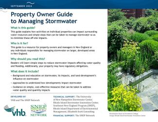
Property Owner Guide to Managing Stormwater
-
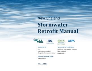
NE Stormwater Retrofit Manual
-
BMP Accounting and Tracking Tool (BATT) (USEPA)
Questions? Contact RIPDES Stormwater Program at DEM.RIPDESMashapaug@dem.ri.gov
The Problem with Stormwater
About Stormwater
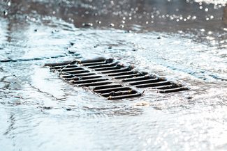
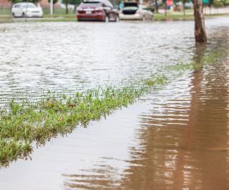
Stormwater runoff is rainwater that doesn’t soak into the ground and flows over streets, sidewalks, parking areas, driveways, and yards into nearby streams or rivers. As it flows, it can carry pollution like fertilizer, pet waste, motor oil, pesticides, trash, and dirt. These pollutants can end up in local waterways, where they may cause excess algae to grow. These algae can use up oxygen in the water, make it cloudy, and release toxins that harm fish, birds, and other animals. In some cases, the toxins can also make people sick. If stormwater runoff isn’t managed, it can lead to serious problems with water quality and may force the closure of nearby ponds, rivers, or recreational areas.
Pollution from stormwater runoff in the Mashapaug watershed has led to high levels of phosphorus and bacteria (like fecal coliform), along with low oxygen levels in the water. These conditions have caused harmful algal blooms that have made the ponds unsafe and often forced them to close to the public. Since 2011, there have been around 20 health warnings due to these blooms in Mashapaug, Spectacle, and Tongue Ponds, with some lasting for several months.
The area around the Mashapaug watershed is a densely built-up urban zone with a lot of pavement and concrete, which prevents water from soaking into the ground. This leads to heavy stormwater runoff that picks up pollution and carries it into the ponds. The neighborhoods nearby are considered environmental justice communities, meaning they already face more environmental and health burdens than other areas. These communities have been dealing with pollution for a long time.
Mashapaug Pond is officially listed by the Rhode Island Department of Environmental Management (DEM) as polluted due to excess algae (chlorophyll A), low oxygen, high phosphorus, toxic chemicals like PCBs in fish, and harmful bacteria. Both Mashapaug and Spectacle Ponds have been on Rhode Island’s list of polluted waters (the 303(d) List) since at least 2002.
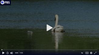
The Mashapaug Pond water quality buoy was launched on July 9, 2025. It collects data every 10 minutes and measures 8 different water quality parameters, all of which help track, understand and eventually forecast potential Harmful Algal Blooms (HABs) in Mashapaug Pond.
It's Not Just Rain
When stormwater hits the pavement, it picks up and mixes with what’s there. That might include:
- oil, grease, and automotive fluids;
- fertilizer and pesticides from gardens and homes;
- bacteria from pet waste and improperly maintained septic systems;
- soil from poor construction site management;
- sand from wintertime snow removal;
- soap from car washing;
- debris and litter.
So, the water flowing down the street is not just rain; it’s polluted water, and it heads directly to our local waterbodies.
You can help!
Individual homeowners and small businesses in the watershed who are not subject to the new permit can also take action at home, at your business, and in your community to help reduce discharges of stormwater pollutants. See RI Stormwater Solutions for tips.
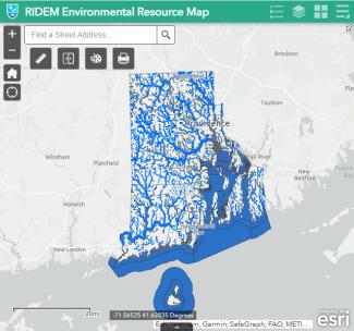
DEM Environmental Resources Map
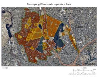
This interactive map shows a variety of information for Rhode Island's communities, including watershed information and impervious surfaces.
The Permit Development Process
Cleaner Water Starts Here
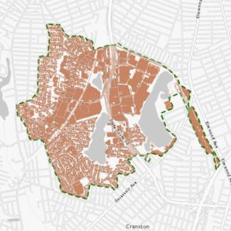
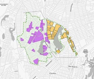
The following is an interactive map showing the properties and contiguous properties in the watershed with an acre or more of impervious cover that DEM identified as being subject to the Mashapaug General Permit. These permittees are required to develop and implement site-specific stormwater management procedures and practices that will reduce or eliminate the discharge of stormwater pollutants. (Note that some properties are exempt from this permit because their stormwater discharges are covered by another permit). Use the Interactive Map Mashapaug Pond Stormwater Parcels below to view the properties and watershed.
Identification of Parcels Subject to the Permit
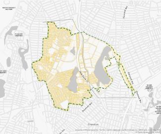
Step 1: Identify Parcels Within the Watershed: First, we selected all parcels intersecting the watershed (shown by the dashed line) using parcel data provided by the Cities of Cranston and Providence.
Step 2: Group by Ownership and Calculate Impervious Cover: Next, we merged properties based on common ownership and adjacency to obtain a true value of the property area associated with each entity. After merging, we calculated the amount of impervious cover (IC) for each property (according to the 2020 URI Environmental Data Center and RIGIS – Rhode Island Impervious Surfaces Layer) and selected all with one acre or more of IC.
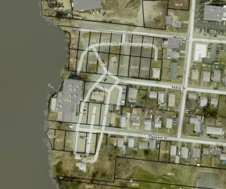
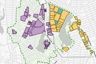
Example: Parcels less than one acre with common ownership: Here, we can see an example of several small lots under one owner, as well as part of a single business entity. Individually, these lots are too small.
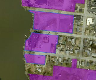
But when merged, they account for 4.1 acres of land, of which 3.2 are impervious cover.
Frequently Asked Questions
Mashapaug Pond is the largest freshwater body in the City of Providence. It is located between Route 10 and Reservoir Avenue, south of Huntington Avenue. The watershed includes Spectacle Pond and Tongue Pond in the City of Cranston. Those ponds are located on the west side of Route 10 on either side of Garfield Avenue. See the Interactive Map for a larger view of the Mashapaug Watershed.
Owners of properties or contiguous properties in the Mashapaug Watershed with one acre or more of impervious surface discharging stormwater runoff directly to waters of the State or through a municipal separate storm sewer system (MS4). Examples of the types of properties identified include businesses, shopping centers, employee parking lots, office buildings, residential apartment buildings, schools, community centers, recreational fields, etc.
Properties (including merged parcels) that will be subject to the Mashapaug General Permit are shown on the Interactive Map. A list of these properties is also available in Table A-1, Attachment 1, of the Mashapaug General Permit’s Fact Sheet below:
If stormwater discharges from your property into a nearby roadway collection system via a pipe, storm drain, catch basin, or other type of inlet, the collection system, otherwise known as a municipal separate storm sewer system (MS4), may be owned by the City of Providence, the City of Cranston, or RIDOT. Each of these entities has publicly available GIS mapping of their MS4/stormwater collection systems, which may help you determine into which receiving waterbody the stormwater runoff ultimately discharges once it enters an MS4. Access the MS4 GIS mapping using these links: City of Providence / City of Cranston / RIDOT
The "outfall" or "discharge point" is defined as the location where collected and concentrated stormwater flows are discharged from the property such that the first receiving waterbody into which the discharge flows, either directly or through a municipal separate storm sewer system (MS4), is a water of the State. If stormwater runoff leaves your property and discharges to a water of State through an MS4, the outfall or discharge point would be the location where it leaves your property and enters the MS4, not the point where it discharges from the MS4 to a water of the State. On the Notice of Intent (NOI) application form, be sure to provide the latitude and longitude of the point where stormwater leaves the property and enters the MS4. Do not provide the latitude and longitude of the ultimate discharge location from the MS4 to the receiving water.
The Mashapaug General Permit will help reduce the pollutants carried into waterbodies by stormwater, resulting in cleaner ponds and a reduction in harmful algae blooms. These efforts could make neighborhoods greener and more beautiful, with potential benefits such as cooler urban temperatures on hot days due to increased tree planting. Other benefits could include flood reduction, more shade from trees, and carbon capture. For more information on the benefits of these approaches, see www.epa.gov/green-infrastructure.
In accordance with the Rules and Regulations Governing the Establishment of Various Fees (available online at: http://www.dem.ri.gov/pubs/regs/regs/water/feereg07.pdf), for a new general permit application required to submit a Stormwater Management Plan (SWMP) (i.e., properties with seven (7) or more acres of impervious cover), a $400 non-refundable application fee must be submitted with the Notice of Intent (NOI). Use the Application Fee Form available on this webpage.
All permittees are subject to a $100 annual fee. The annual fee applies to all authorized properties active as of December 31st and is due every July 15th for the previous calendar year in accordance with the RIDEM Fee Regulations. Annual Fee invoices and instructions are typically mailed in May.
If you are an owner of a property subject to this permit, it is highly recommended that you subscribe to the Mashapaug General Permit email list to receive direct communication through email regarding the permit: https://lp.constantcontactpages.com/sl/l8BDHwB
If you are a community member, concerned citizen, or other interested party, we also welcome you to subscribe to the Mashapaug General Permit email list.
Individual homeowners and small businesses in the watershed who are not subject the new permit can also take action at home, at your business, and in your community to help reduce discharges of stormwater pollutants. Please visit RI Stormwater Solutions for tips on what individuals and businesses can do to be good stormwater stewards in the watershed.
Related Links
- Stormwater Management: City of Providence / City of Cranston
- Tax Assessor's Parcel Data: City of Providence / City of Cranston
- MS4 GIS Mapping: City of Providence / City of Cranston / RIDOT
- Stormwater Innovation Center
- SNEP Network
- RIDEM Environmental Justice
- Mashapaug Pond Water Quality Buoy Data Dashboard
- 2024 Rhode Island Integrated Water Quality Monitoring and Assessment Report
- Rhode Island’s 303(d) List of Impaired Waters
- EPA's Residual Designation Authority
- Regulations for the Rhode Island Pollutant Discharge Elimination System (RIPDES) Title 250-RICR-150-10-1
- Rhode Island Stormwater Design and Installation Standards Manual
- Rhode Island Low Impact Development Site Planning and Design Guidance Manual
- Rhode Island Water Quality Regulations (250-RICR-150-05-1)
- RIDOT Stormwater Control Plan (SCP) for Spectacle, Mashapaug, and Roger Williams Park Ponds – Mashapaug Pond (Providence, RI) dated December 30, 2017
- URI Environmental Data Center and RIGIS – Rhode Island Impervious Surfaces Layer (2020)
- RI Green Infrastructure Project (USEPA)