
Community Scale Air Toxics Monitoring Project – Port of Providence and Surrounding Communities
Rev. 3/13/24
2020 Final Report
The final report for the project has been completed. See the attachment below. Public presentations will include a project summary, assessment, and the next phases of monitoring in the Port of Providence.
Project Background
Air quality surrounding the Port of Providence is impacted by air pollution from diesel trucks, marine vessels, oil and gas storage and distribution, asphalt and cement processing, metals recycling, natural gas and utility service, and large heating plants.
Additionally, Interstate Route 95 (I-95) passes through Providence neighborhoods with among the highest poverty and childhood asthma rates in the State. The goal of this Community-Scale Air Toxics monitoring project is to characterize air toxic emissions near the Port of Providence and its potential impacts on the people living and working in the area.
Public health officials have recognized that structural racism in the form of redlining, planning, zoning, industrial siting, and lack of institutional power have resulted in low income and communities of color being disproportionately negatively impacted by environmental hazards, including air pollution. The Port of Providence and the surrounding industrial areas hold regional energy and economic significance, yet present local impacts that are often in conflict with surrounding communities. Communities living close to the highway, port, freight transportation corridors, and industrial areas with more emission sources tend to be more vulnerable to increased exposure to air pollution and the negative health effects.
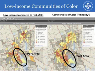
The study will provide valuable information about air pollution levels in communities located adjacent to the Port. The affected communities located closest to the Port are generally low-income communities of color in Providence who bear most of the burden of port-related emissions and suffer the greatest environmental health consequences of air pollution. In Providence, the affected communities generally include the Indigenous, African-American, Black, Latinx, and Southeast Asian communities. There is particular emphasis on people of color who are refugees and immigrants, people with criminal records, those who speak languages other than English, and LGBTQIA+ individuals. The EPA’s Environmental Justice Screening and Mapping Tool (EJSCREEN) is a useful tool for identifying the affected communities. As seen in the map below, EJSCREEN identifies many affected communities, including residential areas (i.e. South Providence and Washington Park) located in close proximity to the Port
Children are also more sensitive to environmental conditions. For example, they are more sensitive to air pollution because their lungs are still developing, and they breathe more air per unit body weight than adults do. This can lead to long-term health impacts. People who already have respiratory health conditions such as asthma and chronic obstructive pulmonary diseases are more susceptible to the impact of pollution.
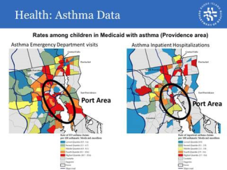
The graphic below shows that the east side of Providence has a much lower rate of children living with asthma compared to the rest of the city. A prior Community Scale Air Toxics monitoring study entitled "Evaluation of the Impact of On-Road Mobile Source Air Toxics on Air Quality at Sensitive Receptors Adjacent to Interstate Route 95 in the Providence Metropolitan Area," evaluated air quality associated with highway traffic. Data from that study indicates that ethylbenzene and xylene levels may be influenced by emissions from port activities and that emissions from the Port should be further evaluated. This new study picks up where some of this previous study left off. Read more about the Near Road study here
Levels of air pollutants measured at the State’s Near Road site, which is adjacent to I-95 in Providence, are consistently considerably higher than those at all other sites in the State . Individuals who reside in South Providence and Washington Park – all predominately low-income communities of color located in close proximity to the Port – represent the majority of asthma-related emergency room visits
In 2010, RIDEM OAR conducted monitoring in and around the Vartan Gregorian Elementary School, that demonstrated particle count impacts on the side of the school downwind of the Port were significantly higher than on the other side. Funding was limited for that study and only particle counts were obtained. Recently, community leaders have expressed concern about current air pollution levels at the school and the results of this study will help further characterize air pollution level at the school, as well as areas surrounding the Port. The monitoring data collected in this study will provide us with valuable information on the level of toxic VOC emissions in areas adjacent to the Port that can be used to reduce unnecessary pollutant exposures.
RIDEM OAR intends to work with representatives of community groups to ensure that the study addresses community concerns and that the results and recommendations are widely communicated. At the end of the study, the monitors, will be available to address future issues identified by community members.
Project Details
The RI DEM Office of Air Resources in conjunction with the RI DOH Air Pollution Laboratory is conducting a Community Scale Air Toxics Monitoring study after successfully applying for and receiving an EPA grant. The study aims to characterize air quality and levels of volatile organic compounds and air toxics in the vicinity of schools, hospitals, residences, and recreational facilities in the areas surrounding the Port of Providence. In addition to monitoring for common pollutants found in port environments, fuel and chemical use data will be collected from industrial sources in the vicinity of the Port to determine air pollution emissions from these sources. Additionally, these sources will be inspected for compliance with Air Pollution Control Regulations.
Interactive Map of Monitoring Sites Around the Port of Providence
Click on map icons to read additional details
Interactive Map of Land Uses Around the Port of Providence
Click on map icons to read additional details
Most Recent Air Emissions Inventory Data from Sources Around the Port of Providence
Below is a summary of the most recent data on air emissions from sources located around the Port of Providence. This data will be updated as data becomes available.
What is Being Monitored, How, Where, and When?
- PM 2.5 and NO2– monitored 24/7 with readings every 15 minutes using Clarity Nodes.
- Air Toxics/VOCs– 24-hr samples will be collected once every six days using Summa Cannisters and EPA Method TO-15A/TO-15.
- Meteorology – monitored 24/7 at Providence Community Health Center, Providence Animal Shelter, and Suez Pump Station using Rainwise MK4-C equipment.
Interactive Map with Real-time Status of Air Quality at Monitoring Sites Around the Port of Providence
Click on map icons to read additional details
Source Inspections
Below is a list of recently completed air compliance inspections and results from sources located around the Port of Providence. This information will be updated as inspections are completed.
- Armbrust International, Bananagrams, Beech Tree Labs, Inc., Country Tire Shop, Crisloid Plastics, Inc., Custom Metal Fabricating, Inc., Delta T Service Corp, E.W. Audet & Sons, EE Weller MCS Finishing, Inc., Ferguson Perforating, Gulfeagle Supply, Heidelberg Materials, Holcim, US, Hook-Fast Specialties, Inc., Ideal Plating & Polishing, International Insignia Corp., Ira Green, Jenni Auto Repair, LLC., J.L. Anthony & Company, Johnson & Wales University (Harborside Campus), Lehigh Metals Corp., Lorac/Union Tool Co., Mahr Inc., McInnis USA, Metallurgical Solutions, Inc., Monarch Metal Finishing Company, Multi-State Electric Co., Narragansett Improvement Co., National Grid LNG, LLC, NBC Fields Point, Pete’s Tire Barn, Quest Pewter Casting, Red House Design Build, Schnitzer Northeast, Shell Oil, Sprague Operating Resources, Stephen T. Haun, Inc., Clean Earth, Technodic Inc., Univar Inc., and Walco Electric.
Odor Checks
- 73 odor checks in 2022, 5 objectionable odors
- 40 odor checks in 2023, 1 objectionable odor
Mobile Air Emissions Monitoring with EPA
During 2021, RIDEM Office of Air Resources Compliance Assurance section and the US EPA National Enforcement Investigations Division performed two rounds of mobile air quality assessments in Rhode Island, with special attention to the Port of Providence. The first round was using the EPA’s DART (Data Acquisition in Real Time) platform, which equipment to measure total VOCs from September 13 to September 17.
The second round of mobile monitoring used a much larger platform named the GMAP (Geospatial Measurement of Air Pollution) to measure a variety of pollutants around industrialized areas from September 27 through October 1, with a special focus around the Port of Providence.
Information from these investigations provided air quality measurements from accessible roadways, both on public and onsite roads of facilities with wind and GPS information. Results from these efforts have led to completed inspections and ongoing compliance work.
Common Pollutants in the Ports – Sources and Health Effects
|
Pollutant |
Sources |
Standard |
Health Effects |
|---|---|---|---|
|
PM2.5 |
Traffic, burning of heating fuels, dust from activities like waste handling, asphalt paving production |
Federal air quality standard |
|
|
Black Carbon |
Diesel-powered vehicles and equipment, industrial processes, burning of petroleum based heating fuels and wood |
No federal or state air quality standard but black carbon is a component of diesel exhaust and PM2.5 |
Health effects include negative effects in respiratory and cardiovascular health, a positive correlation with all-cause hospitalizations and in increase in all-cause mortality from long-term exposure |
|
Nitrogen oxides (NOx)/Nitrogen dioxide (NO2) |
Produced when petroleum-based fuels are burned. |
Motor vehicles are large sources of nitrogen oxides. Nitrogen Dioxide is regulated by a federal air quality standards |
|
|
Benzene |
In gasoline and also produced during the combustion of gasoline. Released from asphalt pavingproduction, crude oil handling and movement of gasoline from terminal storage vessels to trucks. |
No federal or state air quality standard. |
|
|
1,3 Butadiene |
Motor vehicle exhaust, manufacturing and processing facilities, forest fires or other combustion, and cigarette smoke |
No federal or state air quality standard. |
Acute effects may include irritation of the eyes, nasal passages, throat, and lungs |
Questions? Comments?
It is the goal of this project to incorporate any and all public feedback from residents, stakeholders, and concerned citizens. Also, there may be some available monitoring tasks to perform for folks who want to get involved.
For questions or more information please contact the appropriate staff person listed below:
General Information
- Darren Austin (401) 537-4404
- Karen Slattery (401) 537-4396
Complaints or Odors
- DEM Office of Compliance and Inspection (401) 537-4478
Air Pollution Inventory Data
- Alexi Mangili (401) 537-4384
Facility Air Compliance Data
- Joe Carola (401) 537-4405