
Weather Stations
Where is climate data collected in Rhode Island? The National Weather Service, alongside other Federal agencies, maintains weather stations at airports, public institutions, and the homes of volunteers. Additionally, the National Ocean Service operates marine-based observation stations across Narragansett Bay that collect weather, water, and climate data.
Rhode Island Weather Stations
Land Stations
| Station Name | Location | Elevation | Established | Observation Frequency | Parameters |
| Block Island (COOP) | New Shoreham | 130 ft. | 2015 | Daily | Temperature, Precipitation |
| Block Island State Airport | New Shoreham | 105 ft. | 1948 | Hourly | Temperature, Dewpoint, Wind, Pressure, Precipitation |
| Coventry (COOP) | Coventry | 260 ft. | 2011 | Daily | Precipitation |
| Kingston (COOP) | South Kingstown | 117 ft. | 1893 | Daily | Temperature, Precipitation |
| Kingston 1 NW (COOP) | South Kingstown | 115 ft. | 2001 | Daily | Temperature, Precipitation |
| Kingston 1 W (COOP) | South Kingstown | 106 ft. | 2001 | Daily | Temperature, Precipitation |
| Newport State Airport | Middletown | 148 ft. | 1996 | Hourly | Temperature, Dewpoint, Wind, Pressure, Precipitation |
| North Central State Airport | Smithfield | 441 ft. | 1992 | Hourly | Temperature, Dewpoint, Wind, Pressure, Precipitation |
| North Foster (COOP) | Foster | 630 ft. | 1974 | Daily | Temperature, Precipitation |
| Quonset State Airport | North Kingstown | 20 ft. | 1947 | Hourly | Temperature, Dewpoint, Wind, Pressure, Precipitation |
| R.I. T.F. Green Int'l Airport | Warwick | 51 ft. | 1932 | Hourly | Temperature, Dewpoint, Wind, Pressure, Precipitation |
| Westerly State Airport | Westerly | 65 ft. | 1999 | Hourly | Temperature, Dewpoint, Wind, Pressure, Precipitation |
| Woonsocket (COOP) | Woonsocket | 360 ft. | 1948 | Daily | Precipitation |
Marine Stations
| Station Name | Location | Elevation | Established | Observation Frequency | Parameters |
| Conimicut Light | Upper Narragansett Bay | 8.09 ft. | 1999 | 6 mins. | Tides, Wind, Air Temperature, Water Temperature, Pressure |
| Newport | Coasters Harbor Island | 7.03 ft. | 1930 | 6 mins. | Tides, Wind, Air Temperature, Water Temperature, Pressure, Sea Level Trends |
| Port of Davisville | Quonset Point | 9.55 ft. | 2022 | 6 mins. | Wind, Air Temperature, Humidity, Pressure |
| Potter Cove | Prudence Island | 39.37 ft. | 1999 | 6 mins. | Wind, Air Temperature, Pressure |
| Providence | Providence River | 8.96 ft. | 1938 | 6 mins. | Tides, Wind, Air Temperature, Water Temperature, Pressure, Sea Level Trends |
| Providence Visibility | Providence River | 12.69 ft. | 2016 | 6 mins. | Wind, Air Temperature, Visibility, Pressure |
| Quonset Point | Quonset Point | 6.97 ft. | 1999 | 6 mins. | Tides, Wind, Air Temperature, Water Temperature, Conductivity, Pressure |
Types of Weather Stations
Automated (ASOS, AWOS, Marine)
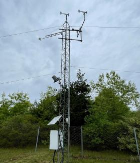
Automated Surface Observing Stations (ASOS) and Automated Weather Observing Stations (AWOS) at airports record hourly temperature, precipitation, dewpoint, pressure, wind, and cloud cover data. Marine stations are also automated and collect weather data and water data (conductivity, tides, sea level trends) every six minutes.
Manual (COOP, CoCoRaHS)

The Cooperative Observer Program (COOP) is a voluntary service where participants collect daily temperature and precipitation data. The Community Collaborative Rain, Hail, and Snow (CoCoRaHS) network is a large organization that provides daily precipitation measurements. There are 115 active CoCoRaHS observers in Rhode Island.