
Biological Monitoring in Rivers and Streams
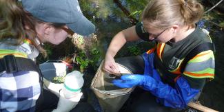
Collecting invertebrates in wadeable streams with a net
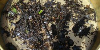
Collection of material from stream water using a net
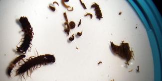
Insect communities are collected, sorted, and identified
A key component of the rotating basin approach to monitor rivers and streams is the RI Wadeable Streams Biomonitoring and Habitat Assessment Program. This DEM program involves the collection and taxonomic identification of macroinvertebrate (aquatic insect) samples from riffle habitat in shallow, wadeable rivers and streams.
Aquatic Macroinvertebrate Sampling
Aquatic macroinvertebrates include immature larval forms of many insects such as dragonflies and damselflies, or benthic (bottom dwelling) animals such as worms and snails, among other organisms. The objective of the program is to collect the macroinvertebrates in the stream with a net, identify them and characterize benthic communities and overall habitat in rivers and streams throughout in Rhode Island. As resources allow, up to 50 stream locations are sampled once annually during a target period from August through the end of September using protocols specified in the program’s USEPA-approved Quality Assurance Project Plan (QAPP).
The macroinvertebrates sampled are good indicators of stream water quality and can be used to evaluate the biological integrity of a stream--its ability to support and maintain healthy aquatic communities, known as “aquatic life use”.
Because benthic macroinvertebrates are relatively sedentary within a stream and spend much of their life cycle in the water, information about community composition accurately reflects local ambient environmental conditions. These biological communities integrate the effects of different stressors providing a broad measure of aggregate impacts and also assimilate the effects of stressors over time, providing an ecological measure of fluctuating environmental conditions.
Macroinvertebrate communities dominated by pollution tolerant organisms or lack of macroinvertebrates sensitive to pollution may indicate “impaired” waters that do not support healthy aquatic communities (“aquatic life use”). Integrating biomonitoring with basic water quality sampling is often regarded as a more cost-effective technique than solely relying on intensive water sampling for multiple toxic pollutants that are highly variable over time.
Detailed technical information about how we use macroinvertebrate data can be found in our Consolidated Assessment and listing Methodology (CALM) document as well as the background information documenting the development of our biological condition index we use as a reference for some of our streams.
Stream Habitat Surveys
When macroinvertebrates are collected from streams, habitat quality is also visually evaluated, quantified and categorized. It is expected that sites with good habitat quality will support healthy macroinvertebrates, whereas poor habitat quality can lead to poor macroinvertebrate health.
Sites that exhibit excellent habitat but show poor invertebrate health, may indicate water quality problems such as nutrient enrichment or other pollution. Marginal or poor habitat indicates areas in need of habitat restoration. Integrating information from water chemistry samples, stream macroinvertebrate communities, and habitat data helps strengthens confidence in water quality assessments and focus restoration planning.
For more information on this program contact Jane Sawyers at jane.sawyers@dem.ri.gov or 401-537-4160.