“Core Forest” Determinations for Renewable Energy Developments

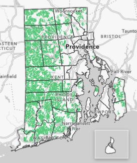
While Rhode Island’s nickname “the Ocean State” captures the state’s image and best-known places, it does not reflect the fact that forests comprise more than half the state’s land area. In fact, over 50% of the state’s land area is covered by forests. An estimated 213,000 acres, or 58% of the forested land in the state, is considered core forest.
One of the greatest threats to Rhode Island’s forests is improperly managed human development. Legislation enacted in 2023 (H 5853 Sub A / S 684 Sub A), as amended in 2024 (H 7431 Sub A / S 2151 Sub Aaa), established requirements governing the siting of renewable energy systems participating in the state’s net-metering or Renewable Energy Growth (REG) incentive programs. That law requires DEM to determine if proposed projects seeking to participate in these programs are eligible based on these siting requirements. Specifically, projects must be sited outside of core forests, as defined in the law, with the exception of development on preferred sites in the core forest. DEM has developed this guidance document to assist renewable energy developers and other stakeholders in understanding the process that will be used to make siting determinations.
Developers of ground-mounted solar and other renewable energy facilities are required to present a siting document to DEM that includes a project base map reflecting Rhode Island’s core forests with the entirety of the installation’s project boundaries overlayed.
Additional Information for Claiming Brownfields as “Preferred Sites”
- Renewable energy developers claiming brownfields as “preferred sites” must provide the DEM Site Remediation (SR) number associated with the site. This information should be clearly noted under “Street Location Information” in the online submission form.
- For purposes of “preferred site” determinations only, DEM will consider the entire brownfield parcel as the “preferred site.”
Submit Siting Document for Core Forest Determination
Additional Resources
Frequently Asked Questions
“Core forest” refers to unfragmented forest blocks of single or multiple parcels totaling two hundred fifty (250) acres or greater unbroken by development and at least twenty-five (25) acres from mapped roads.
Preferred sites are defined as those sites that have had prior development including, but not limited to, landfills, gravel pits and quarries, highway and major road median strips, brownfields, superfund sites, parking lots or sites that are designated as appropriate for carports, and all rooftops.
For systems developed in core forests on preferred sites, the law states that no more than one hundred thousand square feet (100,000 sq. ft) of core forest shall be removed, except for work required for utility interconnection or development of a brownfield, in which case no more core forest than necessary for interconnection or brownfield development shall be removed.
Additional Information for Claiming Brownfields as “Preferred Sites”
- Renewable energy developers claiming brownfields as “preferred sites” must provide the DEM Site Remediation (SR) number associated with the site. This information should be clearly noted under “Street Location Information” in the online submission form.
- For purposes of “preferred site” determinations only, DEM will consider the entire brownfield parcel as the “preferred site.”
Rhode Island’s forests are owned and managed by a combination of federal agencies and programs, state agencies and programs, national and local land trusts and other conservation organizations, and private landowners. Of Rhode Island’s 368,373 acres of forestland, 124,940 acres, or 34%, are protected to varying degrees. An estimated 68% of forestland is privately owned and managed by an estimated 38,000 landowners.
Rhode Island was 67% forested as recently as 1967, but forested area has declined since then as land has been cleared for development. Fragmentation is one of the greatest threats to Rhode Island’s forests and many wildlife species that rely on them for habitat. Forest fragmentation is the breaking of large, contiguous, forested areas into smaller pieces of forest, which are typically separated by roads, agriculture, utility corridors, subdivisions, or other human development.
The Renewable Energy Growth (REG) Program, administered by Rhode Island Energy, supports the development of distributed generation projects in Rhode Island. Eligible technologies include wind, solar, small-scale hydropower, and anaerobic digestion. The program enables customers to sell their generation output under long-term tariffs at fixed prices. Each year the program is revised with new ceiling prices and a megawatt allocation plan. The Distributed Generation Contracts Board, a ten-member board, oversees the REG program and is responsible for developing and recommending the annual program plan.

