
Mature Commercial District -- Existing Conditions Before Development
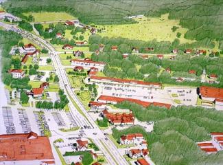
Mature Commercial District -- Introduction to the Site
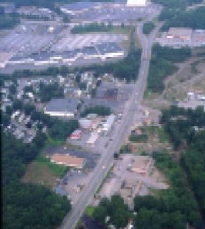
The study area is a older commercial/residential district on the outskirts of Westerly. Bounded by Rt. 1 to the north, Airport Rd (opposite Rt. 78) on the East and Mastuxet Brook to the South, it is a district without a real center, where commercial development along Rt. 1 has brought ever larger stores and parking lots, and continues to put pressure on older commercial buildings and small residential neighborhoods that lie beyond the highway frontage. With the town considering zoning changes to promote office park uses, the area is literally at a crossroads, and landowners and residents must decide whether to try to create a real neighborhood in this location or let it become a typical office and commercial district.
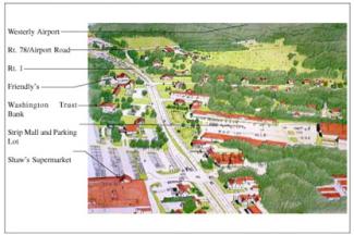
Looking East up Rt. 1 towards Westerly, with Rt. 78 in the foreground, the study area is on the left side of the image.
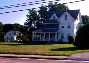
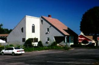
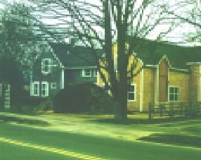
Some large and well-maintained older homes anchor a residential neighborhood in the center of the district.
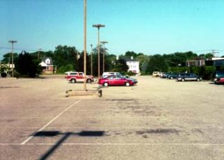
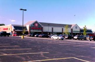
Oversized parking lots that never fill up offer potential infill sites, especially when centrally-located within neighborhoods like this one, where many uses are within walking distance
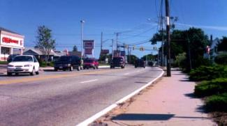
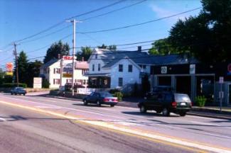
As older houses are first converted to commercial and then replaced by supermarkets and other uses, Rt. 1 becomes increasingly striplike and uncomfortable for pedestrians.
Mature Commercial District -- After Conventional Development
Mature Commercial District -- Conventional Development
With a complex interaction of existing landuses, economic processes, and shifting market forces, older commercial districts defy simple management strategies, and invite big, oversimplified solutions. That was the tragedy of Urban Renewal, which sponsored "slum clearance" to create development sites for large masterplanned development — in the process destroying countless historic neighborhoods in the name of progress. On a smaller scale that process continues here, as supermarkets and office parks are invited in to replace less profitable uses. Meanwhile, what little remained of a real community is further degraded. As this process progresses, increased traffic creates pressure for road widening and intersection improvements, which improve conditions for cars but make the area even more dangerous and uncomfortable for pedestrians.
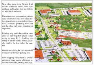
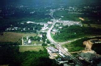
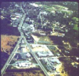
Aerial view of development elsewhere on Rt. 1 illustrates the typical development process; small commercial establishments take over old houses, these are torn down to build larger commercial buildings, which are themselves replaced or killed off by competition from even larger developments.
Older commercial areas often hold a record of decades of changing architectural styles: either a blessing or a curse, depending on your point of view.
"Plenty of free parking!" was and is a commercial necessity; somehow it all ended up in front of the building, which we can no longer see very well, nor walk to.
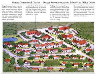
Mature Commercial District -- After Creative Development
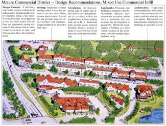
Mature Commercial District -- Design Recommendations, Roadside Development
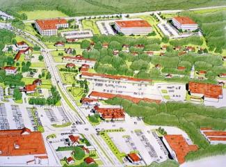
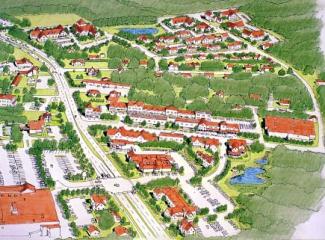
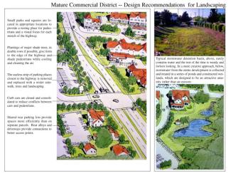
Design Concept: Office park and commercial uses are encouraged to expand, but to do it in a way that enhances the existing neighborhood, rather than tearing it to bits. Structures are smaller, truly mixed-use along streets and within buildings. Infill of underutilized parking areas, renovation of older structures, and rationalized parking and circulation systems tie the revitalized neighborhood together. There are three key areas: roadside development along Rt. 1; a mixed- use office center off Airport Road; and mixed-use commercial infill in the center. A new interior street connects all three areas together. The principal existing roads are redesigned with an eye to more pedestrian use and visual quality for motorists. This would start with removal of paving where possible and planting of street trees.
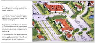
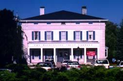
Well-designed structures, like the Washington Trust building (left) are used as the foundation stones of a rebuilt neighborhood. Existing houses along Rt. 1 are also protected (right); needs for expansion are met by building on at the rear, or tying two existing buildings together with a new wing, rather than tearing down and starting over.
Mature Commercial District -- Implementation Techniques and Examples
Proposed rezoning of the area is put on hold until landowners, business people and residents reach a consensus about the future of their neighborhood. Through a masterplanning process, a plan for the district is created to guide future growth in a coordinated manner. This will only succeed if it is produced by the people who own the land and run the businesses, for no amount of wishful thinking will overcome the difficulties of coordinating this effort unless the participants themselves are behind the idea. Once a consensus is achieved, the best thing the town can do is get out of the way; removing regulatory barriers and providing incentives to promote the project. Zoning could be simplified by enacting a single Planned Village Development District that would establish allowable uses, density and dimensional requirements, and design standards for the entire district. These efforts would also need to be coordinated with ongoing comprehensive planning for the surrounding area of Westerly, for it would be difficult to force developers to deal with the complexities of this approach when development is still allowed in green-fields just down the road. Other urban revitalization techniques could also be explored: targeted infrastructure improvements, especially for water and sewer, street tree plantings and new connecting roads; grants for renovation of key buildings; construction of public buildings in the neighborhood to spur activity and investment.
At the time, many new structures used traditional materials (left and below); still, the way they were laid out and sited didn't seem to fit the historic character of the town.
The masterplan establishes specific, though not manditory, locations for new buildings and additions (above) as well as design guidelines for architecture, parking, & landscaping.
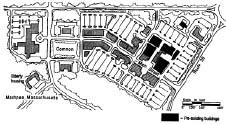
The plan for Mashpee Commons, on Cape Cod, revitalized an old commercial center by building a new Main Street, lined with shops and offices, as the spine of a new village.
Historic Edgartown, on Martha's Vineyard, long struggled to manage strip commercial development along the main road into town before deciding to create a district masterplan.
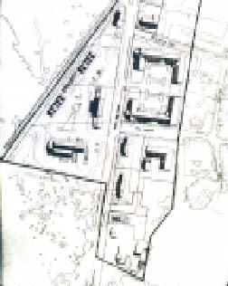
A detailed masterplan for the whole district located all existing structures, roads, and landscaping. Rather than limiting development, the plan proposed filling gaps along the street edge with new buildings, renovating and expanding existing structures, and hiding parking lots. Comprehensive streetscape design and pedestrian enhancements guide development of a pedestrian-friendly shopping district where residents and tourists are encouraged to get out of their cars and walk between uses.