
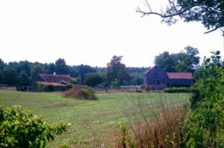
Rural District -- Existing Conditions Before Development
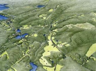
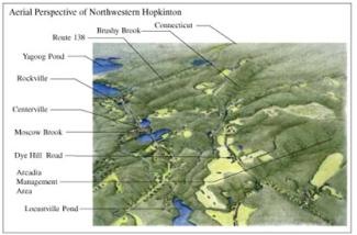
Rural District -- Introduction to the Site
The study area is a rural district in the town of Hopkinton, comprising a mix of open meadows and forested parcels lining Dye Hill Road together with the historic mill villages along Rt 138. Like many rural areas of South County, there is no single dominant element that gives this district its rural character; rather, it results from the having a great variety of natural and historic cultural landscapes close together. In this scenario, natural resources include streams, ponds and wetlands, and several large tracts of undeveloped woodland. Cultural resources include village centers, agricultural landscapes and historic mill sites.
Rural District -- After Conventional Development
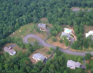
Rural District -- Conventional Development
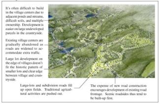
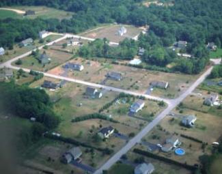
Under current zoning, most of the study area would be developed at a density of 80,000 s.f. per unit. Areas with poor soils, steep slopes and difficult access have not been shown as developed: even so, this uncoordinated large-lot development pattern pollutes water bodies, fragments wildlife habitat, and destroys scenic vistas. Any hope of maintaining existing visual character or quality of life would be lost.
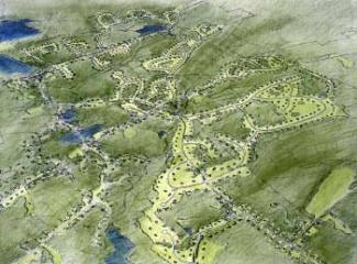
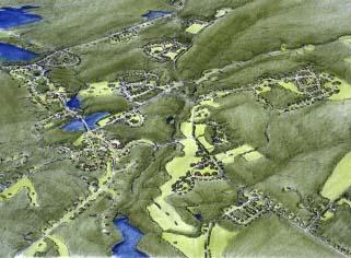
Rural District -- After Creative Development
Rural District -- Implementation Techniques and Examples
The problem posed by conventional development begins with zoning that calls for a uniform wash of two acre house lots, combined with a development process that promotes subdivision of each parcel in isolation from its context. The solution starts with a town-wide greenspace planning process, designed to identify character-defining features and protection priorities ahead of time, so that when development is considered it can be directed away from sensitive areas. Resources to be examined would include natural resources, such as streams, ponds, wetlands and large tracts of forest; cultural resources, including historic village centers, agricultural landscapes , and mill sites; and recreational resources, such as hiking and bridle trails, town and state park land, etc. Through a process of mapping, discussion with town residents, and testing of alternatives, the town arrives at a greenspace plan that defines priorities for protection, and more importantly sets down a vision for an interconnected network of open space that protects special resources while directing growth to the most appropriate areas.
The creative development alternative illustrated uses two forms of cluster development to shift the same number of units allowed under current zoning to areas more appropriate for construction of new homes. These are both described within the Model Zoning Ordinances prepared for the South County Watersheds Technical Planning Assistance Project. The first method uses Conservation Subdivision Design to define protected open space first, then to locate homes and the roads that serve them, and finally lot lines. With an emphasis on protected open space, this is best for agricultural and forested landscapes. The second approach, designed for parcels in or near existing villages, is called Flexible Development. It focuses less on open space protection than on the character of the community that is possible with greater site planning and design freedom.
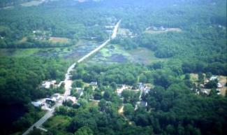
With the Greenspace Plan in place, residents, planners, and developers have a tool for decision making as properties become available for development. Infill of existing villages, development of new centers, and carefully-located large-lot development can be used to preserve open space resources while reinvigorating older town and village centers.
At the same time, the town's comprehensive planning efforts should continue to examine the larger issues posed by growth. It may be, in fact, that there are simply too many new houses allowed by current zoning for the carrying capacity of the land. In that case no amount of creative design will solve the problem, and more direct conservation measures will be needed: fee-simple acquisition of ownership; purchase of conservation easements; limited development; or a transfer of development rights program to purchase development rights for sensitive lands and send them to areas where growth makes more sense.
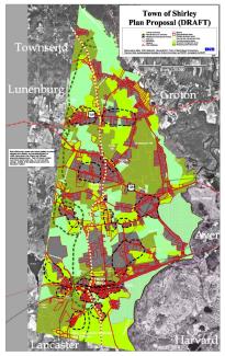
A recent comprehensive plan update in Shirley Massachusetts resulted in this greenway-based proposed future landuse plan. After extensive GIS resource analysis and a series of public workshops, a conceptual greenway plan was prepared locating important natural and cultural resource corridors. This was translated into a parcel-specific landuse plan, shown above, in which every parcel in the town was assigned a specific designation for managed development or permanent conservation as open space.