Chapter 2 - Towards Better Planning and Design for South County
Introduction
When we arrive at a place, through birth or immigration, we rarely give a second thought to where it's been or where it's going. As with our human acquaintances, the past and future of places can seem irrelevant to the day-to-day concerns of life, and we simply accept a place for what it is. When people think about building a house, or a subdivision, or a shopping center they generally approach it the same way: here is the site; here is what the zoning says I can build; here is my plan. Hundreds of such decisions, and thousands more that don't require any public review or approval, are made every year in South County. None of these are bad in themselves, but without the perspective of past and future, without reference to some coordinating plan, they are bound to produce an effect which, in aggregate, is at best a hodge-podge. In rural areas of South County, where growth is fairly moderate and incremental, this lot-by-lot approach to planning and development seems to be adequate. Yet as the pace of change quickens, people are starting to realize that other people's land use and design decisions have a direct bearing on their everyday lives, and that poor planning and design is not only ugly, but inefficient, and costly to use and maintain. Likewise, while most people enjoy access to larger houses, bigger stores, and generally more choices, the quality of their lives does not necessarily seem any better, and the beauty of their surroundings is often worse.
Now, every town has a Comprehensive Plan, which is supposed to provide for a coordinated approach to development, to balance demand for services with supply, and so on. This in turn is meant to be implemented through the zoning map and ordinances. So why are these tools not working better? In some towns, the plans and regulations simply have come to the wrong conclusion, and consciously promote forms of development that will never be appropriate. But the larger problem is that comprehensive plans and regulations focus primarily on planning, at the scale of the whole town, while the decisions that really matter are made in design at the scale of individual sites. Between the site and town scales, and between planning and design, there is often little communication, and sometimes conscious separation.
Much of what is needed, therefore, are ways to integrate design into the planning process at the scale of the town, and even the region, and conversely to bring planning policy down to the level of the site. This approach makes possible forms of development that are more complex, more adaptable, and ultimately more livable, where uses and users are mixed to a much greater extent, and where natural systems and cultural patterns share the same space to the mutual benefit of both. It also allows us to better understand historic patterns of development and the lifestyles they supported, which were often not consciously "designed", but which nevertheless evolved into a complex, but clearly structured form.
The results of this approach, and many specific ideas for building more livable communities, are illustrated in the design scenarios that make up Chapter 3. By way of introduction to the specific scenarios, however, what follows is a brief overview of the landscape of South County and how it got that way, along with an outline of the way development forces, in the last few decades in particular, have changed that landscape. Several overarching design principles are introduced that are common to many of the design scenarios, including the concepts of mixed-use development and pedestrian-friendly design. These are then placed in the context of planning approaches, including Greenspace/Greenway Planning and Neighborhood Design, that help to bridge the gap in scope and scale that has traditionally made it hard to connect town-wide goals with site-level decisions.
As demonstrated by the design scenarios in chapter three, towns need not adopt these ideas wholesale; they can and should move gradually, first to allow and then perhaps to encourage the creation of mixed-use, walkable centers with a balance of housing, jobs, community services and amenities. In the not-so-distant future, towns that encourage this sort of development, particularly those that make it possible for people to live at least partially without their cars, will have a dramatic advantage over those where the car is a necessity for daily life. The fact that these livable communities will look better, be more socially diverse, and economically stable will be the key to maintaining and enhancing the quality of life for all residents of South County.
Nature, Culture, and Rural Character
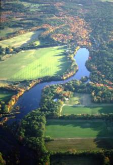
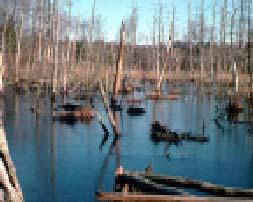
As stated in chapter one, South County is a beautiful place because of a unique combination of natural and man-made features interacting over time. There are pristine natural environments, like the Pawcatuck River and its tributaries, and the salt marshes along the coastal plain. There are also marvelous cultural landscapes, by which we mean working agricultural districts, historic farms and estates and village centers. There are many theories about what makes natural areas and wilderness beautiful: partly it's because of the associations of health and vitality, and our simple joy in observing nature. On a more abstract level, nature is beautiful because the way things look is a direct reflection of underlying physical processes, which produce a stimulating visual variety within an overall sense of order. For example, a meandering stream can create a series of curves and channels with no identical parts; yet each meander shares similar forms and geometries, themselves a record of processes that follow strict physical laws. Likewise a grove of trees, a flock of birds, or a field of grass waving in the wind expresses limitless variety within an overall pattern or theme.
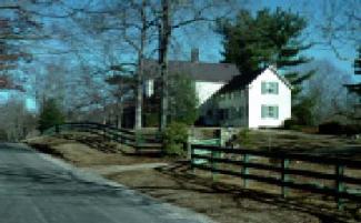
Man-made, or cultural landscapes, are often beautiful for the same reason: expressing an underlying order that results from, and is a visual record of, physical processes and relationships. Historic landscapes are further bound together by a reliance on muscle power for construction, a dependence on a few hardy species of plants and animals, and a direct physical connection to natural resources. Thus an historic farm landscape tells the story of the size of fields that could be cleared, plowed and planted by hand and animal power; walls and barns constructed from native stone and timber; and crops and livestock adapted to local climate and conditions. Old South County villages and harbor towns appeal to us, not just because they are quaint, but because we recognize the underlying order, the union of form and function, that created them. Because they were built at a time when everything had to be done by hand, moreover, their narrow streets and human-scaled architecture reaches out to us in a personal way that more recent streets and buildings do not.
The interaction of these two separate systems, the natural and cultural, enhances the beauty and interest of both, and explains why working landscapes in rural areas are often favorite tourist haunts. Within a short distance of any small South County village, you can still walk from a dense Main Street lined with buildings, to an area of fields and pasturage, and continue to relatively wild forest, wetlands, or rugged hillsides. Along with these rings or tiers of different landscape types, elements of each often run through the others, as when a mill village is cut through by a natural stream corridor, or orderly farm fields are interrupted by a wooded ravine. Part of the charm of this woven tapestry is its organic quality _ you couldn't plan it or create it from whole cloth, the only way it happens is by slow interaction and growth over many years. Which is why it needs to be carefully protected.

It has been argued that there is no longer such a thing as "rural," that almost all areas of the country exist only to serve the large urban centers. By this argument all of South County is a suburb of Providence, or exists as a summer home for people from Providence or other cities. And to some extent this analysis explains why, despite relatively low development densities, the rural character of the region is disappearing. As South County towns become bedroom communities for urban centers, as they become more dependent on industries that do not use local resources — other than the human work force — the principles that used to provide order to the landscape disappear. There is no longer a functional relationship between land and water and human livelihood to support a corresponding visual relationship between homes and businesses and the land around them.
So as traditional rural activities, like farming and forestry, occupy a smaller percentage of the landscape, how do we protect the rural visual character they once created? One way is to support farm and forest activities, and many towns are doing that. But another way is to identify and support new kinds of functional relationships that can serve to bind towns and villages to their surrounding landscapes. The most basic of these functional relationships is the link between the town center and its surroundings for water supply, stormwater management, and sewage disposal. We have learned to hide these functions, like the plumbing in our houses, behind closed doors and veils of euphemism _ what if, instead, we celebrate them and use them as a focus of the community? For instance, instead of diverting stormwater to pipes and culverts and detention basins surrounded by chain link, we can construct naturalized ponds and wetlands that help remove impurities while at the same time becoming the focus for new public parks. Rather than just watching the water disappear down a catch basin, residents observe the flow of water from driveways and roads as it travels from their street into their neighborhood park system. Under such circumstances, few people would be inclined to dump oil or trash at the curbside. Likewise, wells and septic systems are now largely private and individual _yet shared water supply and sewerage are often cheaper and cleaner _ what if we encourage the use of these alternative systems, and then make them part of the visible fabric of neighborhood open space? Again, the key is to allow the function of the system be connected to the visual experience of living in a place _ not that people want to see their sewage, but why not allow them to understand that the meadow at the entrance of their town also contains the recharge fields for the treated wastewater that originates from their homes, and that this water cycles back into the aquifers that provide their sole source of drinking water. Right now these truths are anything but self-evident, which makes it easier to think about your home and neighborhood as an isolated entity disconnected from the surrounding landscape.
Other functional relationships that can be used to reinforce the visual structure of the landscape include the use of open space by residents for recreation, food supply, even building materials and energy supplies. Obviously, you can encourage walking and bicycling from homes and businesses to commercial centers, schools, libraries and town halls by building hiking, biking, and riding trails that link residential areas with community centers and main streets. This is already part of subdivision planning in some towns. What if those subdivision plans also included provision for community gardens, or even agriculture at the scale of a small farm? What if wood lots were maintained for the use of residents in cutting their own firewood or timber for construction? This involvement of residents in the process of food production and resource management is fundamental to life in truly rural areas; why shouldn't it be part of maintaining rural character in South County? Each of these examples represents a functional activity that will have a corresponding visual effect in the maintenance of rural character _ not as a museum of petrified landscape, but as a living, organic relationship between people, plants, animals, and the landscape.
Many towns say, in their Comprehensive Plans, that they want to protect "rural character," but it is rarely defined, and perhaps can't be. It includes the visual contrast between dense, walkable town and village centers and the working landscapes that surround them. It also flows from the recognizable patterns that are created by working relationships between people and the landscape. Development can continue without changing this rural feeling _ to a point. The first thing to disappear is the functional relationship between people and the landscape, as farming and forestry die out as major activities. And even after these functional ties have been severed, the appearance of rural character remains, if only as an empty shell. That too is a fragile balance, for at some point _ perhaps when subdivisions begin to outnumber fields and forests _ towns no longer even look rural. To put it another way: when developed areas are surrounded by open space you have rural character, when open spaces are surrounded by development you have suburban character.
Suburban Sprawl
How did we get to the point where everyone agrees they want to save rural character, but everything we do seems to destroy it? We have seen that the rural landscape was created by a series of ongoing and interdependent relationships between people and the landscape, largely based on agriculture and the direct use of natural resources. The industrial revolution changed this equation: first, by removing the reliance of manufacturing on water power, and second, by introducing new forms of transportation that allowed manufacturers to be far away from their sources of raw materials, and for workers and managers to live at a distance from their places of employment. This process was magnified many times by the introduction of the automobile, which has totally changed the American landscape. 75 years ago, planners thought that cars would simply provide another way of getting from one village, town, or city to another, and promoted the creation of parkways to link existing centers. This evolved into the Interstate Highway System. Along the way, however, everyone discovered that improved roads and highways not only linked existing centers, but opened up millions of acres of "empty" land for development, and very soon the genie was out of the bottle for good. Driven by the market place, and subsidized by trillions of dollars in public investment in highways, suburban development became a self-replicating machine. This has done enormous good, of course, in bringing the proverbial dream of home ownership to millions, but with many unintended consequences. Where the process has advanced to the point of extensive, uncoordinated and dysfunctional development, it is termed "suburban sprawl."
South County is still only part way down the road towards suburban sprawl, but certainly heading in that direction. It is not going to happen overnight, but in most recent development the typical sprawl patterns of automobile-dependence, separation of uses, and uncoordinated planning are well in evidence. The existing landscape, meanwhile, is treated as a blank slate: "undeveloped land" to be "improved." Recent development in South County, meaning just about everything in the last 50 years, replaces the complex web of natural and cultural landscapes described above with a monotonous pattern of suburban shopping plazas, commercial strips, and subdivisions. "Planners" spend most of their time reacting to development proposals that have been shaped by zoning ordinances designed primarily to create safe roads and limit overall development, but rarely shape growth to any well-thought-out ends. The marketplace is given free-reign, for the most part, in determining the scale and character of development.
The effect is most dramatic in the commercial development along the older highways, where the efficiencies of scale valued by retailers favor large blocky buildings and acres of asphalt. As can be seen in several areas along Route 1 outside Westerly or Wickford, residences are first replaced by small commercial properties, these in turn are consolidated into larger shopping centers, which themselves are replaced or simply put out of business by large super-centers. On the ground, this has given us the place-less suburban commercial strip, where businesses try to out-compete each other with ever larger signs in order to be seen in the fast moving chaos. Pedestrians, meanwhile, are relegated to a no-man's land in between the street and the parking lots - meaning nobody dares walk anywhere. So-called "big-boxes" like Wal-mart are often seen as villains in this process, but they have appeared on the scene only after a long process in which retailers of all kinds sought to serve the largest number of people at the lowest cost. Arguably this is good for the consumer, but it is only possible because of the subsidized highway network that makes the regional big-boxes accessible to a large number of people. Office and industrial development responds to the same pressures for large scale and ease of access. Recognizing that offices don't require the visibility of commercial structures, some bright person invented the "office park," a separate, landscaped development where business can thrive free from conflicts with residential or other uses. The only problem is that same separation means that everyone has to drive to get there.
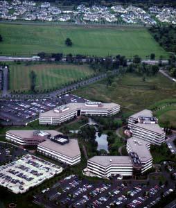
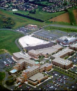
The Carnegie Center Office Park in Princeton, N.J. (left), was a model when it was built, with landscaped parking lots and lush interior courtyards; limited to office use, however, and miles away from shopping, restaurants and workers' homes, it is entirely dependent on the automobile. Nearby, Forrestal Village (right) takes a step in the right direction, combining an office park with shops, restaurants, hotel, even daycare in one compact, pedestrian-friendly development: but there are no residences and you have to drive to reach it, so it's still not a real village.
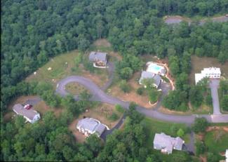
In residential development it is much the same story, as developers feed the housing market by buying large tracts of land at wholesale prices and retailing individual house lots. Cities and towns have traditionally managed this development through zoning and subdivision regulations that, in an attempt to make the process fair and equitable to all landowners and manageable from the town's point of view, limit densities and design approaches to an extremely narrow list of alternatives. This has resulted in most of South County being zoned for 1 or 2 acre house lots on 26 or 30-foot wide roads, with predictable results: one subdivision is much like any other, with no relationship to the surrounding landscape, whether it's a sensitive environmental resource or an historic village center. This can cause trouble with water quality adjacent to ponds and streams. It can also ruin the visual character and quality of life in village centers, where the new single-use subdivisions are the exact opposite of the quaint, walkable streets and mixed-use convenience found in historic villages. Common solutions to this problem, such as cluster development, are often of only limited use in protecting open space and rural character, largely because they rearrange open space and buildings on individual parcels with no recognition of the larger landscape. Even when the preserved open space provides some public benefit, the design of roads and buildings tend to follow suburban models. On the ground, these projects are often little more than cramped versions of standard subdivisions: it's no wonder that many people don't support cluster zoning.
Driven by market forces that reward standardization, residential, commercial and industrial development has been simplified to a few simple models. For all forms of development, builders are often required by local land use ordinances to modify a site to fit a proven plan rather than to custom-design a plan to fit the vagaries of different sites. Those who would do so are often stymied by local regulations that encourage the simple, tried-and-true solution, even if it doesn't quite fit the site. Understandably everything is designed with the worst case in mind: the subdivision road must be wide enough for emergency vehicles; the parking lot must be large enough for the day after Thanksgiving; the house lot must be large enough so that septic effluent will be suitably diluted before it finds its way to the neighbor's well.
Whole books have been written about the shortsightedness of much of the recent development in America: this manual is about how to achieve better design on every project, right here in South County. It begins with planning on the town and regional scale that makes the existing landscape more of a factor in the development process. It includes moving beyond the market forces of the past and thinking about new markets for pedestrian-oriented, mixed-use development. It speaks to a movement away from an orientation on the isolated home or business, and towards design of the whole neighborhood or community. Perhaps most importantly, it requires a planning and design process that integrates these factors, so that design decisions on the site scale reflect an understanding of the site's larger context, and so that regional plans and zoning allow the flexibility and creativity at the site scale for growth to continue in the organic way that created the communities we love.
Smart Growth for South County
The solutions to the problem of suburban sprawl are many and varied, and depend on cooperation between public and private interests, developers and regulators, private citizens and professionals from many fields. This design manual illustrates some new approaches to planning and design on the site, neighborhood, and town scale which, combined with and supported by progressive planning and regulatory practices, can help new development fit in better. This manual does not purport to provide all the answers, or even to touch on many of the creative solutions that people all over the country have put forward; but it is hoped that by studying the design scenarios people can get an idea of how these ideas can be applied, even on a small scale, right here in South County.
The relevance of these ideas is suggested by a recent publication by the Washington County Regional Planning Council entitled: "A Shared Future — Washington County in 2020." This vision for the future of the county centers on "communities creating desirable places to live with vibrant village centers, permanently-preserved natural areas, peaceful farmlands and forests, and sparkling rivers, streams, and beaches." Within this overall vision, the project identified five key planning goals: water quality; village centers surrounded by open space; healthy economy; diversified housing choices; and safe, efficient transportation. How do you move from identifying these objectives as a matter of policy to implementing them on the ground? The traditional comprehensive planning approach would be to develop separate plans and implementation actions for each objective, often with little connection between them. This can lead to conflicts. To prevent contamination of groundwater by septic systems, for example, towns sometimes increase lot size and setback requirements, which spreads houses out more, resulting in loss of open space and less efficient transportation. Likewise, pursuing economic development often means promoting luxury housing, office parks, and golf courses - making it harder to maintain open space and diversity in the housing stock.
The problem is, it's very difficult, intellectually as well as politically, to reconcile within a single scheme the sometimes conflicting goals of economic development, environmental protection, affordable housing, etc. It's difficult to even understand how each piece works by itself, let alone in combination with all the others. So towns do the best they can. Yet there is a growing body of theory and techniques describing a better way to manage the complex task of building more livable communities while protecting our natural resources. United under the banner of "Smart Growth," these concepts include a huge range of ideas, from best management practices at the site scale to national land use and regulatory policy. Like any movement designed to gather many smaller efforts into a single theme, Smart Growth has sometimes been misused by those trying to merely give sprawl a more acceptable face. But its essential tenets still provide an immense leap forward in planning practice. In an article in the April, 2001 issue of Planning (American Planning Association, Chicago, IL), Anthony Downs reviewed the work of smart growth groups across the country, including what he called anti-growth, pro-growth, better-growth, and inner-city philosophies. He identified 14 basic elements advocated by some or all of these groups which represent the core of the approach. Of these, four were shared by most groups:
- "Preserving large amounts of open space and protecting the quality of the environment."
- "Redeveloping inner-core areas and developing infill sites with new and renovated structures to make them more attractive to middle and upper-income households, and to improve the quality of life for existing low-income residents."
- "Removing barriers to urban design innovation in both cities and new suburban areas by encouraging pedestrian-friendly communities, mixed land uses, town centers, and other design elements that make communities more interesting."
- "Creating a greater sense of community within individual localities and neighborhoods and a greater recognition of regional interdependence and solidarity throughout the entire metropolitan area." (Planning, April 2001, p.23).
The interesting thing is that each of these Smart Growth concepts are based on physical planning and design techniques rather than abstract questions of policy: that is, in making decisions about where to put development or where to prevent it, how to layout streets and make strong neighborhoods, and how to combine commercial, residential, and civic uses within walkable development centers. In each of these areas, design - the process of giving order and structure to a given set of elements, and deciding on the physical size, shape, and dimensions of each part as well as the whole is critical to a successful outcome. This is not design as in decoration, but rather design as one end of a continuum directly connected to planning. As stated above, suburban sprawl, and its various manifestations, does not result from poor planning so much as from too little planning planning that stops short of making the critical connection to the design activities necessary to effectively shape healthy communities.
This physical planning and design approach was fundamental to the South County Watersheds Technical Planning Assistance Project, and it is, of course, the foundation of this design manual. At the town or regional scale, it focuses on Greenspace/Greenway-based land use planning, in which priority conservation areas and connecting corridors of open space form the backbone, or "green infrastructure," of future land use. Within this overarching structure, development is accommodated in new or revitalized town and village centers, with an emphasis on Mixed-use Development and Pedestrian-Friendly Streets. Whether in village, town or countryside locations, community-centered Neighborhood Planning is fundamental to more livable communities. And even in Rural Districts, creative approaches to design can allow continued growth while protecting and reinforcing the natural and cultural heritage of our rural landscapes.
Using Greenways and Greenspaces to Shape Community Plans
Assuming towns decide to move away from an approach to zoning that allows a more or less equal wash of development across the entire landscape, means must be found to identify those areas that should be protected, as well as the locations where development might continue. Again, each local Comprehensive Plan has begun this process, but rarely to the extent of offering much guidance on the neighborhood or parcel level. The concept of Greenspace or Greenway Planning can fill this gap by looking in detail at priorities for protection of individual sites, while at the same time linking these parcels with continuous open space corridors.
As organized in an ongoing effort called the South County Greenspace Protection Project, the process begins by a careful analysis of three distinct resource types: natural resources, such as wetlands, aquifers and wildlife habitat; cultural resources, such as farmland, scenic vistas and historic rural landscapes; and recreational resources, like hiking trails, ballfields, and fishing sites. Protection priorities for each of the three resource themes are mapped out first, then overlaid with each other to identify the most important open space parcels, as well as the potential linkages between them. This approach avoids the sort of "single-issue" open space planning that can happen when plans are prepared by a town board or state agency concerned with only one type of resource.
The result of this approach is an open space plan that defines what is sometimes called "green infrastructure:" a network of areas and corridors that protect both the natural systems that support wildlife and clean drinking water, as well as the cultural landscapes and scenic vistas that make each town special. By linking this network to a system of trails and recreation areas, the open space becomes doubly valuable to the life of the community. The Greenspace/greenway plan also serves to inform town-wide plans for development: making clear, for example, where a proposed subdivision or office park will damage an important community asset, as well as shaping how those developments might be designed. This connection between town-wide open space planning and site design is illustrated in many of the design scenarios in Chapter 3, with the caveat that most of these were prepared based on some assumptions about what the Greenspace plan would recommend.
Mixed-use Development
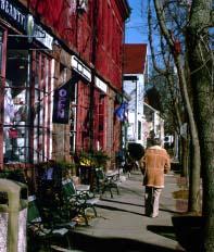
Mixed-use development, which generally means residential, retail, and office uses in close proximity, has been part of the fabric of South County since colonial times. Like the rest of the country, the approach fell from favor as people sought the American Dream of a house in a quiet residential neighborhood, with the noise and congestion of the commercial and industrial centers at a comfortable distance. This distance, however, makes it hard to get to the stores, offices, and municipal services that people need. Along the way the public also realized that shopping malls and office parks, aside from their parking lots, are pretty nice places to be. In the 1980s and 90's this led to a convergence of interest and many experiments in mixed-use development around the country. Cities like Providence, which had always had mixed use, brought retail development back downtown; suburban shopping mall developers started to add uses like office, space, daycare and housing to the typical mall's tried and true retail, restaurant, and entertainment formula. Perhaps most telling has been the recovery of hundreds of small town Main Streets, with old mixed-use commercial blocks with ground floor retail and offices and apartments above.
Common sense tells us that mixed-use development is better for people and better for the land, but it needs to be tied into a larger planning process that uses the flexibility in locating and designing new development to preserve key resources and make communities that work better. In the absence of this larger planning context, mixed use projects can become nothing more than a souped-up version of a shopping mall; very nice once you get there, but still cut off from the larger community. Often these projects win awards and are the subject of books and magazine articles, but they will never be as successful as living communities, and they can fail economically as well. Like other forms of development, mixed-use centers are best planned as part of a study of town-wide transportation systems and existing centers of development. Users and markets need to be carefully defined, and flexibility built in so that if one segment of the market changes another can step in to takes its place.
That flexibility and diversity is the hallmark of the traditional Main Street mixed-use area. The buildings were often based on the same basic block, with storefronts at the base and flexible space above, all based on a simple module of space. Within these blocks, all kinds of uses are possible, so if one use fails another can come in to takes its place. By contrast, many forms of recent corporate development focus on a custom designed building and site plan that only works for a particular use. If the need for that use ends the building is little more than a white elephant. The other problem is that these corporate chains usually place their facilities on the basis of access and visibility out by the interchange, for example so when the supermarket is killed off by an even larger one at the next interchange, not only is the old building unsuitable for a different use, it's in the wrong place as well. So while towns are understandably reluctant to discourage even somewhat chancy commercial development, it makes a lot more sense to encourage the creation of a flexible commercial infrastructure at the same time, so that if one use fails, the building owner can lease it to another.
The hard part, then, is to plant the seed for mixed-use in good soil. Like planting the $5 tree in the proverbial $10 hole, a well-placed mixed-use center will grow, organically, of its own accord, without major public investment or subsidies. It should be the logical center of larger area a gathering spot for the surrounding countryside, where people can easily come together to work, shop, play, learn, etc. Obviously it should be a crossing point of transportation, ideally of several kinds, so that if gas gets too expensive people can still get there by other means. It's no accident that the smallest hamlets arise at a crossroads, or where a road comes down to a river or harbor. All kinds of needs flow from such a situation and every world center started out from something that simple. With a good location, it is often best to set some basic ground rules and get out of the way, without defining uses or dimensions too tightly. What evolves under these conditions is naturally socially and economically diverse, serving many different people doing a lot of different things throughout the day and evening.
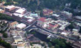
So what are we describing? A real town! This will be true regardless of scale or extent. Benton MacKaye, one of the first regional planners, thought of it this way: to be complete and functional, every town has to have what he called "the five senses:" home, church, school, government, and commerce. Real towns have these things, and it makes them both more livable, and more beautiful. Think of Boston or Providence, Cambridge or Northampton, Westerly or Wickford. The problem is, these places evolved organically, usually because of the presence of some natural resource or transportation nexus. But they also benefited from careful public investment in infrastructure, roads, and amenities. To build successful new mixed-use centers we may need not only to find a good location, but to provide support by building water and sewer systems, roads and parking lots, parks and playgrounds, etc. This may seem a burden on the taxpayer, but it is no less a burden than that posed by the investment we all make in maintaining roads and infrastructure and municipal services to more dispersed forms of development.
Pedestrian-Friendly Design
One of the corollaries of mixed-use design is that it works best if people get out of their cars and move around on foot. Some of the most successful historic centers, as well as new centers like the shopping mall, work because it is easier and more enjoyable to walk, even some distance, than to drive _ the act of walking becomes part of the pleasure of the experience. This involves a number of functional and aesthetic shifts in our approach to planning and design, however, which can sometimes seem to conflict with day-to-day common sense. For instance, successful town centers often struggle with traffic congestion and parking shortages. The common sense solution is to widen roads and build more parking lots. Towns that have dealt with these problems in existing development try to avoid them in new areas by requiring roads and parking standards with plenty of extra room. These approaches, of course, tend to erode the historic fabric of existing centers and spread new development out more so that people have to drive, rather than walk, resulting in the need for more roads and parking, etc., etc.
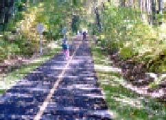
One way to avoid this vicious circle is to make alternative forms of transportation part of the planning mix from the beginning. It is not necessary nor even practical, in rural areas to make everyone leave their cars at home and ride their bikes or take public transit, but if only 10 or 20% do so it might be possible to make existing roads and parking work well enough. And while it may not be possible to serve everyone with shared transit systems, the first step is to make it possible to access these systems from a few central points. Thus, a number of tourist towns have established parking lots on the periphery of the village, with shuttle bus service to the pedestrian core. Larger businesses can provide shared commuter vans for their employees. And the most direct approach of all is to eliminate the need for cars by promoting residential development within walking distance of the commercial/service core.
With a pool of pedestrians ready to walk, the next step is to make it physically possible for them to do so in comfort and safety. Sidewalks and/or paths need to be well made and attractive, and most of all continuous. Even a simple dirt path will suffice if it gets people to where they need to go. Planning for pedestrian access truly needs to be a public/private partnership, with sidewalks along the road providing the principal links, with private connections to individual structures. Critical to this effort is cooperative planning between neighboring parcels, for often the shortest and most comfortable route is directly across the lot line rather than along the street.
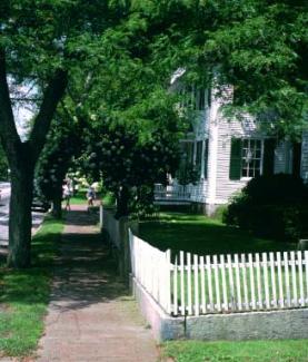
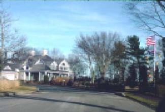
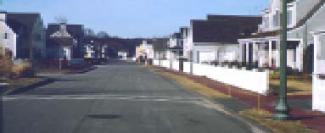
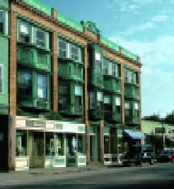
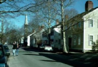
Whether in residential neighborhoods (Kingston, left) or commercial centers (Wickford, right), pedestrian-friendly design is based on the design of the whole streetscape, where individual uses and buildings are subordinated to a larger composition driven by the public space along the street. In the pleasant environment that results, people neither need nor want to drive as much, which means more business for local shops.
The final element deals with the comfort and aesthetic enjoyment of the users. Construction materials and path alignment needs to be sturdy and handicapped-accessible, at a minimum. Traditional paving materials like brick and stone can meet these requirements while adding visual character and connection to local history. Fences, benches, lighting, trash containers and other "street furnishings" also add to the pedestrian experience. Trees to provide shade, and shrubs and flowers for scent and appearance provide amenity. Together, these elements make it possible to walk, rather than ride, but more importantly more enjoyable to do so.
Neighborhood Planning
As stated earlier, despite larger houses on more land, and all sorts of conveniences and aids to our daily activities, most suburbanites feel like there's something missing. Perhaps some of the answers can be found in the lives and communities of previous eras. How was it possible, for instance, for people to live rich, fulfilling lives without automobiles, cell phones and fast food? What can we learn from the design traditions of historic architecture and town planning that can make new homes and communities work better? This is not to say that the past holds all the answers (or that the muddy streets and piles of horse manure common a hundred years ago were anything to write home about) — but, constrained by nature and the technology of the time, the people who originally settled and developed South County learned some useful lessons about living and working with the land, about building efficient communities that could be sustained over generations with the least possible input of energy — lessons that were literally set in stone and left behind for us to discover.
To these historic examples we can add a century of innovation and experiment in the modern tradition of architecture and town building. From the city beautiful movement of the 1890's, to the "new towns" of the 1920's and '30's, to the many innovations in architecture and city planning since, there are numerous ways to improve on the standard practices of site planning and construction, which are often based in generating short-term returns while ignoring livability and long-term sustainability. By thus learning from the past, and combining the best examples with modern techniques and technologies, we can once again build communities with the quality and longevity of which South County's first settlers would approve.
Both the historic examples and more recent innovations share a focus on the neighborhood as the basic unit of design. Just as open space planning can be greatly enhanced by thinking in terms of greenway corridors and ecological systems, design of subdivisions or commercial development can be improved by planning for the neighborhood of which it is or will be a part. Most of the theory of The New Urbanist movement, in fact, concerns the design of the neighborhood. This emerges from a realization that designing for one lot, or even one street, does not produce a livable community to do that you have to focus on the larger structure. The neighborhood is the key, because it is the lowest common denominator of community planning everywhere, whether in a rural context (where the neighborhood becomes a hamlet or village), or in the city, where the neighborhood can be just a few streets out of a city of millions. Mixed use generally makes for better neighborhoods, which can include most of the things that people need on a daily basis housing, retail, services, government, housing, recreation and so on, within a well-organized physical structure that provides security, functionality, and beauty.
A strong physical structure is critical to making neighborhoods that work well and look good. Like a living cell, a neighborhood needs an edge to hold it together, a membrane of some kind to keep the rest of the world at bay while allowing some things to enter. And just as a cell has a nucleus to organize activities and focus energy, a neighborhood needs a vital center, the nature of which can vary widely. It can be a group of buildings, a town square, a market plaza, etc. Along with these two basic ideas, the center and the edge, neighborhoods often share other organizing principles, which can revolve around a function, such as Main Street Commercial or Educational Campus, or a natural feature, such as a river valley or hilltop. These ideas might not seem to apply in a rural area of Exeter or Hopkinton, but they do _ the neighborhoods might be more spread out, but they often have edges, centers, a mix of uses and a social structure as complex as any Brooklyn street. That's why new subdivisions in rural areas can upset the apple cart so badly — not only do they not fit in visually, but they throw off the underlying structure of the neighborhood.
What follows is that in order to design subdivisions and other forms of development that do fit in you need to understand the existing neighborhood structure. Every new development needs to be designed to support that structure, and often can be the catalyst to creating a strong neighborhood structure in areas that are only part way there. Carefully designed new subdivisions or commercial developments can therefore actually enhance the visual character and livability of existing neighborhoods, rather than posing the threat that they often do. It's a lot to ask individual landowners or developers to prepare this sort of study, so part of the process is to bring town planning down to the level of individual neighborhoods. The Greenway/Greenspace planning method described above can do that for open space and recreation; a necessary parallel step is to develop consensus, and in some cases detailed masterplans, for development areas. Thus you look at conservation and development together at the neighborhood scale, identifying neighborhood center and clear edges. If you can get that far, implementation is fairly straightforward, perhaps allowing flexibility in lot size or dimensions to encourage infilling; targeted infrastructure improvements, construction of parks and other public amenities, etc.
Design for Rural Districts
Rural areas are rarely "designed" in the sense that city centers or suburbs are laid out by professionals with specific aesthetic goals in mind. As described earlier, they more often evolve organically as the result of people working the land over many years, resulting in a particular kind of beauty. As long as traditional land-based activities continue, this rural character remains, but as uses change and areas become more suburbanized, it is hard to retain the sense of place and history that draws people to rural areas.
Yet it is possible to understand these landscapes using the same tools that designers apply to more urban situations. These help to define the visual and underlying functional structure of the rural landscape, and point the way to finding ways to allow some growth and development to continue without destroying them. A few basic principles introduce this idea:
- The character of rural areas is defined by a sense of development surrounded by open space. As soon as it becomes open space surrounded by development it no longer looks rural or "works rural."
- Rural areas have a functional relationship between the built environment and the surrounding landscape. This functional relationship is expressed in every aspect of the visual design, whether it is the layout of a farmstead, the design of a mill village or railroad hamlet, etc. When new development lacks these functional connections it no longer looks like it fits in.
- Development in rural areas has by necessity evolved according to the carrying capacity of the land, the availability of resources, and the transportation network. When this carrying capacity is exceeded you quickly erode the functional and visual character of that landscape.
- Rural neighborhoods often have a well-organized social structure which, while more spread out than their urban counterparts, is equally complex.
- Like successful urban environments, rural design has a human scale, in which every element bears the mark of human hands, and a visual relationship to the size and strength of the human body.
- Rural areas are underlain by a complex ecological, cultural, and visual structure that is a rich source of design. Just as urban designers use concepts like Kevin Lynch's nodes, corridors, edges, districts and landmarks to define the anatomy of the city, the rural designer needs to understand the existing visual and functional anatomy of the rural landscape if he or she is to design successful new development.